


Felista Gor explains how sonar technology can assist in discovering wreckages lost in the very depths of the ocean.
The evening of March 8, 2014, was no different from any other for Malaysian airlines. The busy airport was bustling with passengers boarding and disembarking planes as always. However, this day was the beginning of an astonishing event that baffled the entire world.
In the evening of that fateful day, Malaysian Airlines Flight MH370 took off from Kuala Lumpur bound for Beijing carrying 227 passengers and 12 crewmembers. The flight was supposed to take approximately six hours; however, 38 minutes after takeoff, air traffic control lost signals from the plane’s surveillance radar. Later, the primary Malaysian military radar detected the plane for about an hour before it deviated away from the stipulated flight path and eventually vanished.
Following the incident, Malaysian authorities had to devote resources and use the latest underwater technology known as sonar to conduct the most expensive underwater search in history in the days and even years that followed.
Sonar Technology
As the saying goes “Water is life”. Ocean water is vital as it is used for all aspects of life, from regulating temperature to supporting all life. The ocean has also supported the infrastructure, trade, commerce, and growth of many countries. But even with our high reliance on the ocean, about 80 per cent of the vast underwater world remains unexplored, unobserved, and unmapped.
When an airplane crashes into the ocean, it can take months or even years to find the wreckage, if at all. The thought of searching through the ocean to discover the wreckage of lost airplanes is compared to finding a needle in a haystack. The difficulty of conducting such an operation has encouraged researchers to rely on the latest underwater technology called sonar.
Sonar, short for sound navigation and ranging, is a technology used to explore and map the ocean. It uses sound because sound waves travel farther in the water than radar and light waves. It was first introduced in the early 20th century, and because it was expensive, it was only used for military purposes or highly funded research institutions. Increased affordability over the years has opened doors to new capabilities, as in the case of Malaysian airplane search.
How Sonar works
Sound navigation and ranging technology work on the principle of echo. It is fitted with a transducer that emits high-frequency sound waves referred to as ping. Sound waves are then released into the ocean, and when they strike any object at a certain distance in their path, the propagating sound waves reflect. The reflected sound waves are commonly known as “echoes.” The transducer, an electronic device that converts energy from one form to another, converts the reflected sound waves into readable signals, making it easier to locate objects in the ocean. It then measures the strength of the signal by figuring out the time between the emission of the sound pulse and its reception. The transducer then determines the range and orientation of the object and its exact location.
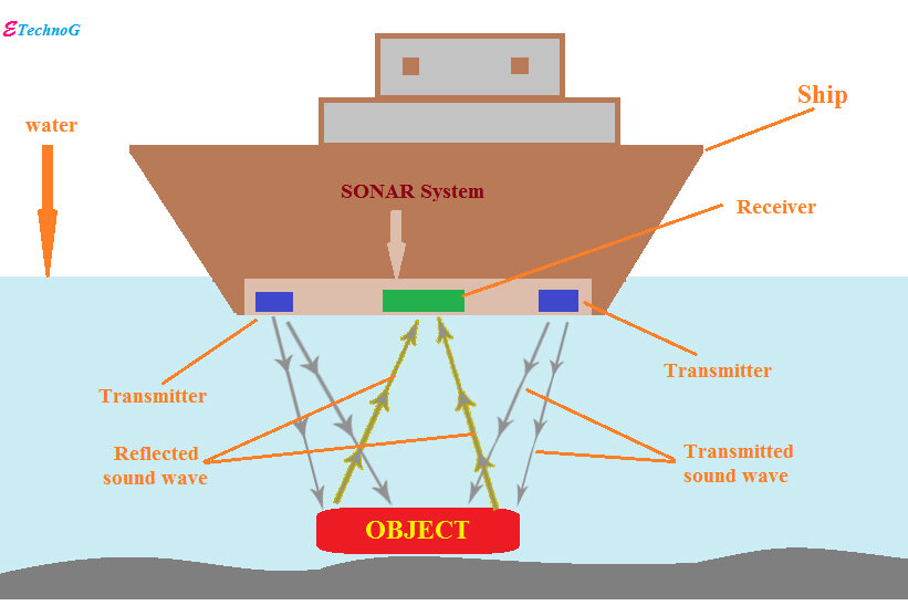
The sonar technology then develops nautical charts that paint the sea floor in a fan-like pattern that creates a finely detailed three-dimensional map that shows the ocean floor details, including ocean depth, bottom type, and topographic features.
Side-scan sonar systems were used to search for the Malaysian airplane MH370. This primarily involves attaching sonar sensors and transducers to a vessel, which is then deployed underwater. The vessel emits sound waves, which are then captured as echoes that are reflected from the ocean floor, including any objects within or near its path.
The data collected through this process was then translated into a detailed map and images of the ocean floor, which helped identify any debris and underwater features that could potentially be used to trace the aircraft. This information was used to narrow down the search area to the west coast of Australia along the Indian Ocean.
The operation also involved the use of autonomous underwater vehicles equipped with side-scan sonar. Autonomous underwater vehicles can be termed “underwater drones,” as they are used to navigate a specified, programmed path. These robotic systems use vision sensors to perform fundamental tasks like navigation, object recognition, and manipulation. For the search of MH370, they were used to map and access areas that were difficult to reach with large search vessels, as well as produce high-resolution images of the programmed areas.
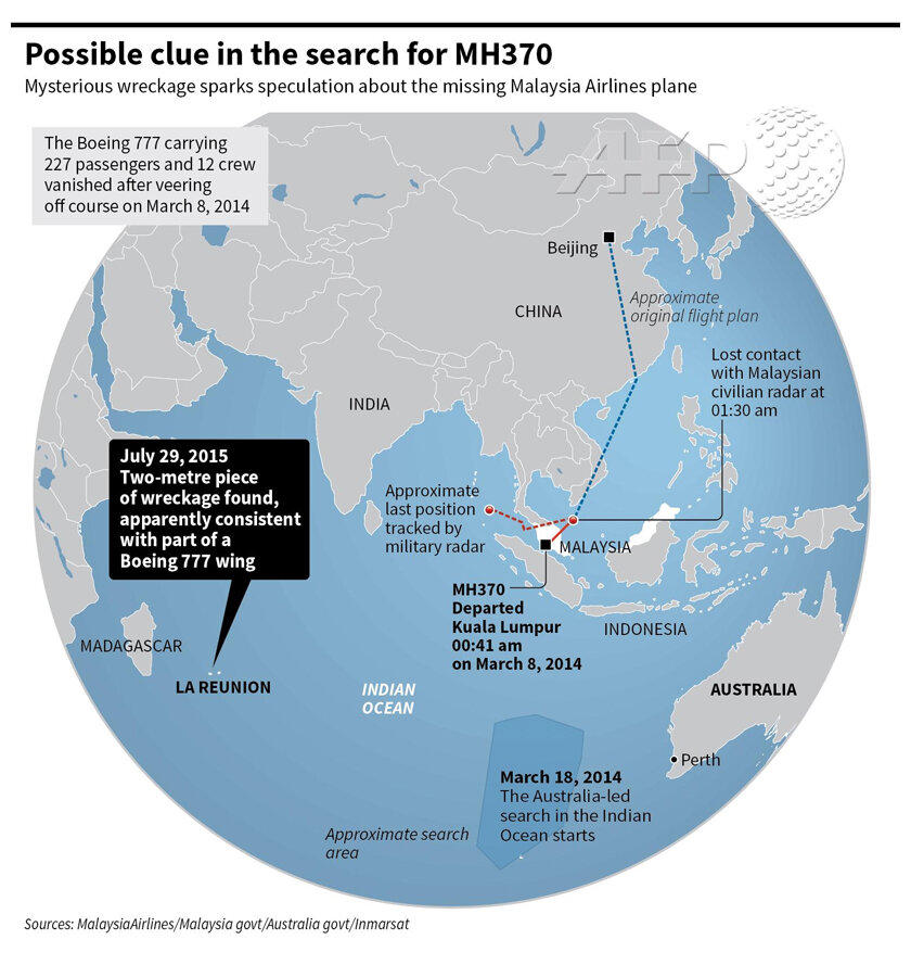
Initial searches were unsuccessful because the plane was thought to have crashed in the Indian Ocean in a region that had never been explored, the terrain was difficult to navigate, and the search area was quite large. However, subsequent searches led to the discovery of plane wreckage near Mozambique, which investigators say, “is most certainly the wreckage of Malaysian flight MH370”.
The bottom line
There is no doubt that the search for MH370 remains one of the most complex and difficult aviation mysteries in history. Although this may seem contradictory, sonar technology has played a significant role in underwater searches. Thus, we have gained a better understanding of the ocean, and the technology has enabled us to search for and locate sunken ships, like the Titanic found in 1985, and the slave ship Clotilda found in the Mobile River in 2019.
In case you missed:
- None Found


5 Comments
Good
Good Story
Good to read
This is such a good discovery especially to someone like me who likes to know the mysterious occurrences that have occurred from time to time.Good job Felista .
Great piece Felista